
CRASH COURSE IN SEISMOLOGY: PANAMA
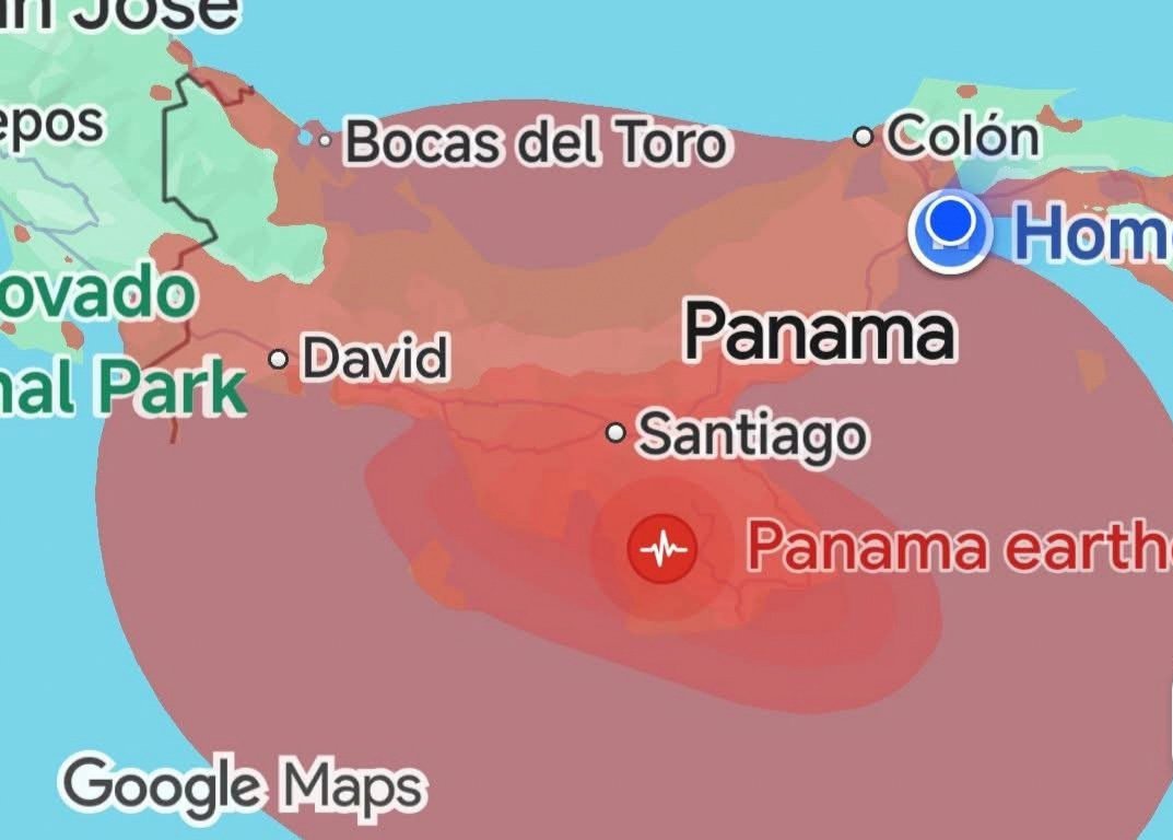
I will be the first to admit that I’m a nerd and am super-prone to deep-dives down various rabbit holes, so here I am writing an article about earthquakes in Panama. Given the recent 7.7 magnitude earthquake that rocked Panama on Friday, October 9th, I decided to do a little investigation. I want to know the everything from the why, how and will it happen again? This is my crash course in seismology, Panama.
Panama may be world-famous for its engineering marvel—the Panama Canal—and its lush rainforests, but fewer people know about the complex geological engines grinding beneath its soil. In fact, I was under the impression that tectonic events are practically non-existent here. Most local tour guides will make the obligatory stop at Arco Chato in Casco where they explain the site’s pivotal role in choosing Panama as the optimal location for the transcontinental canal given the country’s lack of seismic activity. This little tidbit gave me a false sense of security.
October 9th was a reality check. Over the past three years in Panama, I’ve experienced three earthquakes. That’s three more than I ever felt in Georgia back in the United States.
PUTTING THE PIECES TOGETHER
To understand earthquakes in Panama, imagine the Earth’s outer shell as a giant puzzle made of enormous pieces called tectonic plates. These plates move slowly over the planet’s hotter interior. Where they meet, slide past one another, or push against each other, stress can build up in the surrounding rocks. When that stress is suddenly released, seismic waves travel through the Earth, producing an earthquake.
THE PANAMA MICROPLATE
Panama occupies a particularly interesting position in this geological puzzle. Unlike countries situated almost entirely on one large tectonic plate, Panama lies on a smaller tectonic block commonly called the Panama Microplate. This block interacts with several major plates, including the Caribbean Plate to the north, the South American Plate to the east, and the Cocos and Nazca plates to the southwest and south.
The movements and interactions of these plates help explain why earthquakes occur in different parts of the country. The geological picture is complex: the boundaries are not all simple lines, and some areas contain networks of faults, folds, and zones of compression.
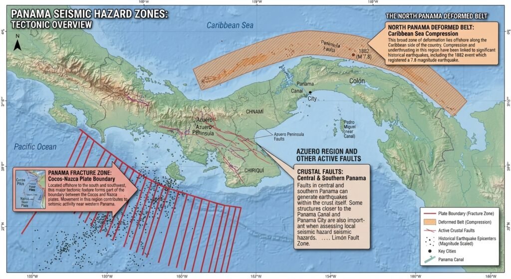
Several features are particularly important:
- The Panama Fracture Zone: Located offshore to the south and southwest, this major tectonic feature forms part of the boundary between the Cocos and Nazca plates. Movement in this region contributes to seismic activity near western Panama.
- The North Panama Deformed Belt: This broad zone of deformation lies offshore along the Caribbean side of the country. Compression and underthrusting in this region have go hand in hand with significant historical earthquakes, including the 1882 event which registered a 7.9 magnitude earthquake.
- The Azuero region and other active faults: Faults in central and southern Panama can generate earthquakes within the crust itself. Some structures closer to the Panama Canal and Panama City are also important when assessing local seismic hazards.
These geological features explain why earthquake risk is not evenly distributed across Panama. Western Panama, particularly the Chiriquí region near Costa Rica, has a well-established history of seismic activity. However, central Panama and the Caribbean coast should not be considered earthquake-free.
The takeaway is simple: Panama’s location between several moving tectonic plates makes seismic activity a natural part of its geology. Hence, it’s best not to be lulled into a false sense of security.
THE VOLCANIC CONNECTION
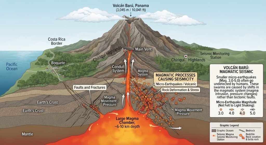
Volcán Barú, Panama’s highest peak and only volcano rises 3,045 meters or 11,041 feet above sea level in Chiriquí south of Costa Rica. Earthquakes are often associated with the presence of volcanoes. In the case of Volcán Baru and the highlands, these smaller tremors are referred to as “volcanic seismic swarms.” These smaller micro-earthquakes usually register around 3.0 to 5.0 and often go undetected by humans. The micro-swarms in this region can usually be attributed to shifts in magmatic systems as opposed to actual quakes along a fault line.
HISTORIC EARTHQUAKES IN PANAMÁ
There have been a few “major” earthquakes recorded in Panamanian history. The most notable took place in 1882 registering 7.9 on the Richter scale. Not only did this monster quake affect Colón and Panamá, it produced a devastating tsunami that struck Guna Yala–the San Blas Archipelago–and temporarily haulted the French canal project.
Another notable earthquake occurred in 1991, in Bocas del Toro along the Costa Rican border. Registering 7.6 on the Richter scale, this massive earthquake altered coastal topography and took out roads and bridges.
ENGINEERING FOR EARTHQUAKES
Many people sang the praises of Panamanian engineering following the earthquake with buildings in the capital experiencing seemingly superficial damage. Building to earthquake code is a serioius matter. With a canal that affects global commerce and hundreds of highrises and skyscrapers in Panama City, engineering safe, resilient buildings is mandatory.
From the outset to the present, the Panama Canal was engineered and built with seismic resilience in mind. The locks, culverts and dams that make up the Panama Canal can withstand major shifts in the earth’s surface without interrupting the flow of traffic through the canal.
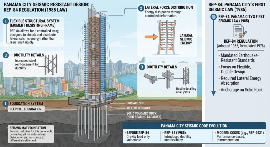
The seismic code established by Panama City engineers in 1976, became law in 1985. As stated in the REP-84 regulation, Panama City construction must adhere to strict earthquake-resistant standards. Under this code, buildings are constructed with a flexible design allowing them to sway with the earth’s movement, safely absorbing and distributing the “lateral seismic energy.”
EARTHQUAKE SAFETY TIPS
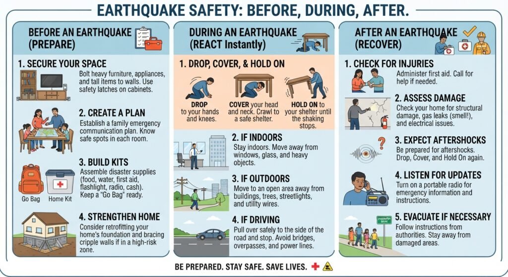
The recent earthquake in Panama, was a good reminder that a little preparation can make a big difference. Earthquakes can happen with little or no warning, and aftershocks may follow the initial tremor. Knowing what to do before, during, and after an earthquake can help protect you and your family. Here’s the before, during and after:
BEFORE
- Prepare an emergency kit: Keep drinking water, nonperishable food, a flashlight, batteries, a first-aid kit, essential medicines, a whistle, a power bank, and copies of important documents in an accessible place.
- Secure heavy objects: Anchor tall bookcases, televisions, mirrors, and other heavy items that could fall. Keep heavy objects off high shelves.
- Identify safe places: Choose sturdy tables or desks to shelter under and identify interior areas away from windows.
- Make a family plan: Agree on a meeting point, an out-of-area contact, and how you will communicate in the event of disruptions in phone networks.
- Know your exits: Identify safe ways out of your home, workplace, or apartment building, and learn where utility shutoffs are located.
DURING INDOORS
- Drop, Cover, and Hold On: Get down on your hands and knees, shelter under a sturdy table or desk, and hold on.
- Protect your head and neck.
- Stay away from windows, glass, exterior walls, and objects that could fall.
- Do not run outside or use elevators while the ground is shaking.
DURING OUTDOORS
- Move away from buildings, walls, balconies, utility poles, trees, and overhead wires if you can do so safely.
- Find an open area and crouch down until the shaking stops.
- Watch for falling glass, debris, and electrical lines.
IF YOU ARE DRIVING
- Pull over somewhere clear of bridges, overpasses, buildings, trees, and power lines.
- Stay inside the vehicle until the shaking stops.
- Proceed cautiously afterward, watching for damaged roads and debris.
AFTER THE EARTHQUAKE
- Expect aftershocks. Be ready to Drop, Cover, and Hold On again if the ground shakes. CDC+1
- Evacuate if necessary. Once the shaking stops, leave if the building is damaged, you smell gas, or authorities instruct you to evacuate. Use the stairs, never elevators, and move to an open area away from buildings.
- Do not re-enter damaged buildings. Wait until authorities or qualified professionals confirm that it is safe.
- Check for injuries and hazards. Help others if you can do so safely. Stay away from fallen power lines, broken glass, and damaged structures.
- Avoid flames if you suspect a gas leak. Do not switch electrical equipment on or off. Move away and report the danger.
- Communicate by text when possible. Keep phone lines available for emergencies and follow official announcements.
TSUNAMI DANGER
If you are near the Pacific or Caribbean coast and experience strong or prolonged shaking, move to higher ground or inland as soon as the shaking stops if a tsunami is possible. Do not wait for an official warning when the natural signs indicate danger, and do not go to the beach to watch the water. Follow designated evacuation routes and official instructions.
ONGOING EFFECTS
Three weeks have passed since the earthquake struck the Azuero Peninsula, marking the beginning of a gradual and challenging road to recovery for Panama. The official figures illustrate the scale of the impact:
- Casualties: Tragically, at least 2 people lost their lives due to structural collapses and related injuries. At least 27 individuals sustained injuries requiring medical attention.
- Displacement and Affected Population: Over 35,000 people have been directly affected. More than 5,000 displaced individuals remain housed across temporary emergency shelters, primarily concentrated in the Veraguas province.
- Infrastructure and Housing Damage: Structural destruction has been severe, with over 2,318 homes completely destroyed and upwards of 6,000 additional residences suffering partial or minor damage. Essential services, local infrastructure, and schools across several affected districts (including Los Santos, Herrera, Coclé, and Veraguas) have faced prolonged disruptions and closures.
HOW TO HELP
If you are looking to support the ongoing humanitarian response and rebuilding efforts, several verified organizations and community funds are accepting contributions:
- The Red Cross Society of Panama (Cruz Roja Panameña): Working alongside the IFRC, they are executing a multi-month response plan providing emergency health services, clean water, and cash assistance to vulnerable households. You can donate through their official national website.
- World Central Kitchen (WCK): Known for deploying rapidly to disaster zones, WCK has been active in providing fresh meals and comfort to affected families and emergency workers. You can contribute directly via World Central Kitchen’s Panama Earthquake Campaign.
- Pedasí, Cañas & Tonosí Local Earthquake Relief: For hyper-local community support coordinated directly by local municipalities (targeting hard-hit areas like Pedasí and Tonosí), international donors can utilize their official GoFundMe Earthquake Relief Fund.
- Panamanian Government Trusts: The national government has authorized official donation trusts and coordination channels (such as through the Ministry of Housing, MIVIOT) dedicated strictly to long-term housing reconstruction
October 9, 2026, will remain an unforgettable day for the many people who experienced this powerful earthquake firsthand. Even three weeks later, daily tremors and aftershocks continue to remind us that the earth beneath our feet is still shifting, while countless lives and communities continue to feel its effects. Panama’s unique geological position along a complex system of tectonic plates and microplates makes seismic activity a natural part of life on the Isthmus. Although significant earthquake damage has historically been relatively uncommon, this recent event serves as an important reminder that we should never take our safety for granted. By understanding the geology behind these events, recognizing the risks, and taking steps to prepare, we can replace uncertainty with knowledge, fear with confidence, and ultimately build a safer, more resilient Panama.